
http://www.weather.com/travel/driving-scenic-drives/ri-rhode-island-coast-20120412
General description: A 61-mile scenic drive along Rhode Island’s coast and Narragansett Bay in Westerly.
Special attractions: Watch Hill, Misquamicut State Beach, Burlingame State Park, Ninigret National Wildlife Refuge, Ninigret Conservation Area, Fort Ninigret, Charlestown, Trustom Pond National Wildlife Refuge, Point Judith, Silas Casey Farm, Gilbert Stuart Birthplace, Conanicut Island, Fort Wetherill State Park, Newport attractions, Cliff Walk, scenic views, hiking, birding, fishing, historic sites.
Location: Southern Rhode Island.
Drive route numbers: U.S. Highways 1 and 1A, Rhode Island Highways 108 and 138.
Travel season: Year-round. The weather along the coast is generally very pleasant. Warm summer temperatures are moderated by sea breezes.
Camping: Burlingame State Park north of US 1 has 755 campsites with water, washrooms, showers, toilets, and picnic tables. Charlestown Breachway offers seventy-five sites for self-contained units. Fisherman’s Memorial State Park at Galilee has 147 trailer/RV sites and thirty-five tent sites.
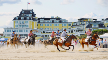
Services: All services in Westerly, Watch Hill, Charlestown, Wakefield, Narragansett Pier.
Nearby attractions: Providence attractions, Lincoln Woods State Park, Connecticut coastline, Mystic seaport, Cape Cod National Seashore.
The Drive
This
61-mile excursion begins in Westerly on the Connecticut border and
roughly follows the Rhode Island shoreline east to Narragansett. Here it
works north along Narragansett Bay, crosses the bay to Conanicut
Island, and finishes in the famed city of Newport at the southern tip of
slender Aquidneck Island. The drive offers pleasant scenery, historic
sites and mansions, dense woodlands, rock-rimmed peninsulas, long sand
spits and beaches, salt marshes, and a maze of inlets, coves, and
harbors.
Rhode Island, nicknamed the Ocean State, is the nation’s smallest state, measuring only 48 miles long by 37 miles wide. More than 20 percent of Rhode Island is consumed by Narragansett Bay, a wide slice of water reaching across the state. The bay encompasses 12 miles of water on the south, narrows to 3 miles in the north, and extends 28 miles inland. Three major islands—Aquidneck, Conanicut, and Prudence—split the bay into two rough halves. The twisting shoreline of the bay, which is the state’s premier natural feature, totals more than 300 miles. The ocean front between Point Judith and Watch Hill is a long, straight stretch of sand beaches, lagoons, and salt ponds.
The scenic drive begins in Westerly, a few miles south of Interstate 95. Take exit 1 and drive south on Rhode Island Highway 3 into the downtown area. The city, as its name suggests, lies in far western Rhode Island along the west bank of the Pawcatuck River, opposite the Connecticut border. It’s a pretty town with tree-shaded streets, elegant homes, and a long history. Besides sharing the placid river with Pawcatuck, its Connecticut twin, Westerly shares the same post office and railroad station. The town was supposedly founded by settlers John Babcock from Plymouth Colony and Mary Lawton from Newport. The lovers eloped from Newport in 1648. Other immigrants followed, settling on this riverbank purchased from local Indians. To tame the wild surroundings, a bounty of 20 shillings was given for every wolf killed in Westerly in 1687.
In later times Westerly flourished with a diverse industrial base, including shipbuilding, granite quarrying, and wool and cotton textile mills. The huge White Rock Company cotton mill, built in 1849 and purchased in 1874 for Fruit of the Loom, still testifies to this prosperity. Westerly’s claims to fame now are the Westerly Sun, the only Sunday evening newspaper in the United States, and the world’s oldest operating automatic telephone system. The city’s downtown has a distinct small town flavor, dominated by eighteen-acre Wilcox Park. More than a hundred tree and shrub species, an herb garden, flower beds, a large pond filled with goldfish, statuary including a marble Christopher Columbus, and a Braille-marked trail are found here. The Wilcox Park Historic District surrounds the park, with charming old buildings and stately Victorian residences. Buildings of note here are the 1872 Old Town Hall, the Romanesque-style Westerly Public Library, and the 1732 Babcock-Smith House. The house, open in summer with limited hours, is a well-preserved pre–Revolutionary War home furnished with period antiques that once belonged to Dr. Joshua Babcock, a member of the state’s General Assembly, chief justice of the colony’s Supreme Court, and a friend of Benjamin Franklin.
From Wilcox Park the scenic drive begins by heading south on Beach Street (U.S. Highway 1A), following signs to Watch Hill. Solid old Victorian houses line the shaded street. The road passes River Bend Cemetery, with many monuments and gravestones of blue Westerly granite, and rolls south over worn granite hills covered with secluded homes. After almost 4 miles, bend right on Watch Hill Road. The asphalt twists southwest through hills for a few miles to Watch Hill, one of New England’s oldest seaside resorts.
This small town at the state’s far southwestern corner is surprisingly unpretentious and quiet. Parking is limited, however, and once the available spots are filled, it’s hard to find anywhere to stop. Watch Hill received its unusual name during the Revolution when soldiers perched on this point and watched for British raiders. Later it became a fashionable resort. Many of its homes and estates with ornate hedges date from the nineteenth century. Bay Street, Watch Hill’s business district, is lined with shops and restaurants. A statue of Ninigret, a 1630s chief of the Niantics, greets visitors on the street.
The Flying Horse Carousel, found at the end of Bay Street, is the oldest continuously operating merry-go-round carousel in the United States. The carousel, also called the Watch Hill Carousel, was built in 1867, spent a dozen years traveling with a carnival, and was finally set up permanently in Watch Hill in 1879. The carousel, unlike modern ones, has no wooden deck. The 140-year-old, hand-carved, hand-painted horses are suspended from above and give the illusion of flying as the central shaft rotates. The horses were carved from single pieces of wood, decorated with agate eyes and genuine horsehair tails and manes, and have leather saddles. Adults are not permitted to ride the carousel; only children whose feet do not touch the ground when seated are allowed. The ride operates through the summer.
Another Watch Hill spot of interest is its popular sand beach facing the Atlantic Ocean. The bathhouse is near the carousel, and beach access is granted to those who have paid the bathhouse fee. A good short walk goes to the 1856 Watch Hill Lighthouse, an excellent example of a nineteenth-century lighthouse. The light is closed to visitors, but nearby is the Watch Hill Lighthouse Museum.
A longer hike is out to Napatree Point Beach and Conservation Area. The 1.5-mile walk to the very western end of Rhode Island follows a long spit of sand that juts into Little Narragansett Bay. It’s a charming hike, with the emerald surf breaking on packed sand, a litter of shells sprinkled on the beach, and the wheeling of gulls on the sea breezes. Protected nesting sites of terns and ospreys are found on the point. Beach houses once lined this long, narrow stretch of land until a disastrous hurricane struck in 1938 and erased them. At the end of Napatree Point are the tumbled ruins of old Fort Mansfield, built during the Spanish-American War.


