

Our Windy Ways
March, April and even early May are always windy months along the shore and this spring is no different – at least in this one regard. Today, as I write this installment, it’s blowing hard out of the southwest and the sea is full of whitecaps. A stiff wind coming in off a cold ocean doesn’t make for the best conditions along the shore and, in fact, this time of year can be a good time to explore South County hiking trails and other attractions that are a few miles inland. There you will find temperatures that can be ten or even fifteen degrees warmer than on the beaches. But the wind is a defining element of coastal Rhode Island and whether it’s in the form of a coastal storm, or filling our sails on a summer’s day, it is part of the fabric of the state.
Nature Abhors a Vacuum
You might remember this statement from high school science and it certainly applies to the atmosphere. In a very simple sense wind is air from an area of higher pressure flowing into an area of lower pressure. A classic example of this is when a nor’easter moves up the coast. Nor’easter storms do not actually come from the northeast, but most often come across the mid Atlantic states and then curve north to follow the coastline through New England. Like any respectable low-pressure system north of the equator, they rotate counterclockwise and as they approach from our south and intensify, air from the northeast spirals in to fill the low-pressure void. As the storm passes and heads out to sea, the wind direction changes – always flowing towards the center of low pressure. Often a high-pressure system with clear dry air will move in behind a departing nor’easter and when there is a sharp gradient between the approaching high to the west and the departing low to the east, a really strong west wind will blow, even as the sun shines.
But the wind I want to discuss today is the everyday pattern that comes with warming weather along our coast. As spring unfolds and morphs into summer, and the sun gets higher and stronger, increasing solar energy fuels a very different wind pattern - one that put us on the map.
Today South County Rhode Island is known for miles of beaches, clear waters and oceans of summer fun, but when we first developed as a destination – back in the 1860’s or so – it was primarily for our natural air conditioning. In the spring and summer, when the sun is high and strong, its warming rays create a different kind of vacuum, one that results in our famous sea breezes.
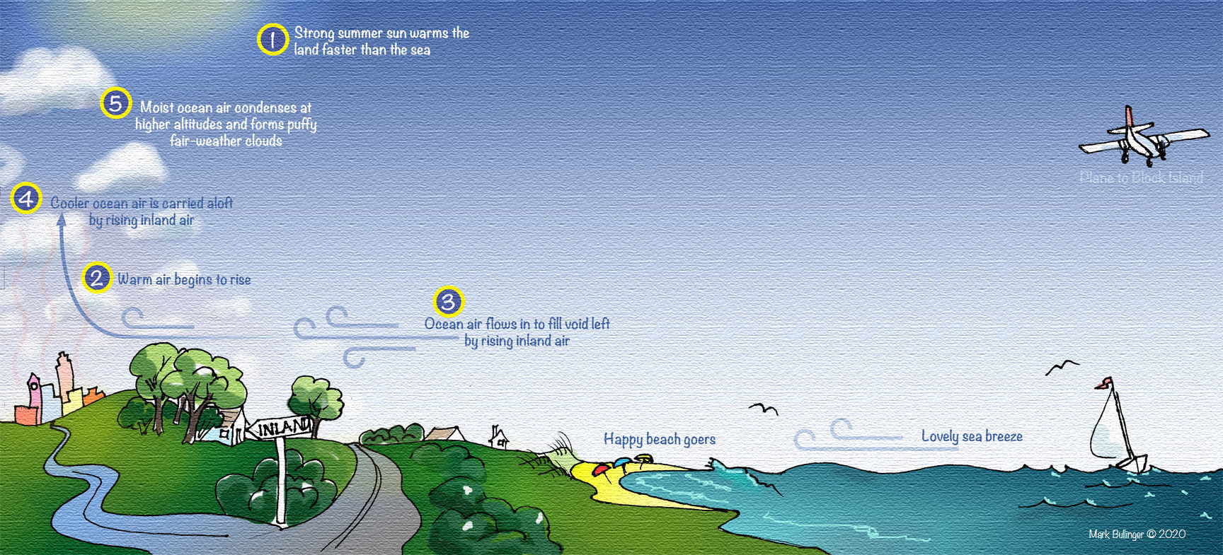
Picture a hot summer day – one where the forecast is for a high of say 90-degrees. 7 a.m. and the sky is cloudless and blue and a calm sea sparkles under the rising sun. Light and variable breezes ripple the sea surface and send the sweet smell of the salt air and honeysuckle wafting around early-morning walkers. As the clock advances through mid-morning, coastal and inland areas are warming fairly evenly and the breeze remain variable and light. But as we get on towards noon, something changes. The sun is really beating down now and inland the areas and the associated air are warming much faster than the ocean. The warming air grows less dense and starts to rise like a hot air balloon and as it does it creates a vacuum. Cooler air over the ocean isn’t rising nearly as fast, but it feels the void and it just abhors that vacuum. Before we know it, cool ocean air is flowing in to fill the void and visitors along the beach start to notice a delightfully cool breeze puffing in off the water. As inland areas continue to warm, and the air rises faster, the breezes become stronger and soon whitecaps are kicking-up out offshore.
By this point beachgoers are loving life. The day is warm, the breeze is fresh, the sun is shining and the ocean glitters and dances in shades of blue and green. Perhaps a sympathetic thought flits through their minds – one about friends and family back home who are enduring stultifying heat or clammy cold air conditioning - but such thoughts soon evaporate in the summer breeze and it’s on to important decisions, such as whether it’s time for a swim or a nap on the beach towel.
By midafternoon visual proof of sea breezes take shape in the form of puffy white clouds ten or fifteen miles inland. They are formed when the cooler, moister ocean air has blown inland and then caught the rising air currents up to where it’s cold enough for the moisture to condense – often in the range of 2 – 4,000 feet. These low-level, fair-weather clouds are called cumulous clouds and they are very common on summer afternoons.
Getting back to the 1800’s. These reliable cooling breezes were very appealing to people who suffered the sweltering heat and humidity of mid-Atlantic cities. No one had air conditioning back in those days and so people who had the means would pack their steamer trunks and board the DC to Boston train and leave cities such as Baltimore, Philadelphia and New York behind. Watch Hill, in particular, was a popular destination, because it checked all the boxes for a refreshing coastal retreat: lovely beaches, sweeping ocean views, busy social scene and the sea breezes. And, its close proximity to the train station, and being the first community in New England facing the open Atlantic, simply made it easier to get to than places further east. And so people came and grand hotels were built and each of them had a wrap around veranda where the more formal generations sat in bowler hats and blazers, or stiff-necked dresses and petticoats, while the less inhibited guests frolicked in the waves.
So this time of year the sea breezes can be pretty chilly, but come summer they make our stretch of coast a little slice of heaven. Come visit us when it’s safe to venture forth and enjoy the sea breezes just like out forbearers did through generations past. You can even ride the train and get off at the same stations they did so many generations ago.
Plan a future trip to South County, RI - there are sunny days ahead.